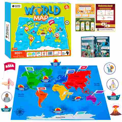
World Map for Kids: Fun and Easy Way to Learn Geography

World Map for Kids: One part of geography that kids will often find tricky is map pointing. It will be hard to remember the name of every country, where each capital is, or which continent a country belongs to. Sometimes, even knowing which ocean touches which land will feel confusing.
That’s why we have made a World Map for Kids. This map shows all the continents, countries, and oceans clearly, so kids will not have to keep flipping through books to remember. They will be able to see India in Asia, Africa surrounded by oceans, or Australia down in the south. Everything will be shown in a way that makes sense at one go.
Kids will be able to point, touch, and explore different places. This will make learning fun and will help them remember things more quickly. If they use it regularly, they will find it much easier to answer questions in exams or quizzes.

Check Out: Kids Experiment Kits
World Map for Kids: Names
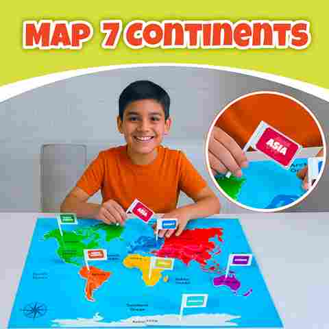
The world is divided into seven main continents, and all the countries are grouped under these continents. Learning about these continents helps children understand how countries are connected and where they are located. While most countries belong entirely to one continent, some nations are partially in two continents, such as Russia and Turkey, which are part of both Europe and Asia. However, here is the list of 7 Continents of the world:-
-
Asia
-
Africa
-
North America
-
South America
-
Europe
-
Australia
-
Antarctica
Easy Ways to Remember Continents and Countries
Here are some Easy Ways to Remember Continents and Countries:-
-
You can make a fun rhyme or acronym:- For example, take the first letters of all the continents (A, A, N, S, E, A, A) and turn them into a silly sentence or rhyme. The sillier it is, the easier it will stick in your mind.
-
Colour your map:- Give each continent its own colour, like green for Africa, blue for Europe, yellow for Asia, or any colours you like. Using colours will make it much easier to remember which continent is which.
-
Use flashcards:- Write the name of a continent on one side and some countries or fun facts on the other. Flip them like a game to make learning more exciting.
-
Play games:- Try puzzles or apps where you match countries to their continents. Turning learning into a game will make it a lot more fun and memorable.
-
Sing:- Make up a little song with all the continent names or some of the big countries. Music helps you remember without even realising it.
Check Out: Kids Activity Kits
World Map for Kids: Fun and Easy Way to Learn Geography
One of the easiest ways for kids to learn about the world is by using a World Map for Kids, where all the continents, countries, and oceans are shown clearly.
1. Asia

Asia is the largest continent in the world. It has mountains, deserts, forests, and rivers. Mount Everest, the tallest mountain in the world, is in Asia, and some of the longest rivers are also here. Asia has many different climates, from snowy mountains to tropical rainforests. It is full of history, culture, and interesting places to explore. Kids can use an interactive world map to see Asia and learn about it in a fun and easy way.
|
Continent |
Countries |
|
Asia |
Afghanistan, Armenia, Azerbaijan, Bahrain, Bangladesh, Bhutan, Brunei, Cambodia, China, Cyprus, Georgia, India, Indonesia, Iran, Iraq, Israel, Japan, Jordan, Kazakhstan, Kuwait, Kyrgyzstan, Laos, Lebanon, Malaysia, Maldives, Mongolia, Myanmar (Burma), Nepal, North Korea, Oman, Pakistan, Palestine, Philippines, Qatar, Saudi Arabia, Singapore, South Korea, Sri Lanka, Syria, Taiwan, Tajikistan, Thailand, Timor-Leste, Turkey, Turkmenistan, United Arab Emirates, Uzbekistan, Vietnam, Yemen |
2. Africa

Africa is the second-largest continent, known for its deserts, such as the Sahara, and wildlife like lions, elephants, and giraffes. It has vast savannahs, tropical forests, and large rivers like the Nile. Africa is full of natural wonders and diverse cultures. Using a world map for students or a map of continents, children can learn about Africa’s geography.
|
Continent |
Countries |
|
Africa |
Algeria, Angola, Benin, Botswana, Burkina Faso, Burundi, Cabo Verde, Cameroon, Central African Republic, Chad, Comoros, Democratic Republic of the Congo, Djibouti, Egypt, Equatorial Guinea, Eritrea, Eswatini, Ethiopia, Gabon, The Gambia, Ghana, Guinea, Guinea-Bissau, Ivory Coast, Kenya, Lesotho, Liberia, Libya, Madagascar, Malawi, Mali, Mauritania, Mauritius, Morocco, Mozambique, Namibia, Niger, Nigeria, Republic of the Congo, Rwanda, São Tomé and Príncipe, Senegal, Seychelles, Sierra Leone, Somalia, South Africa, South Sudan, Sudan, Tanzania, Togo, Tunisia, Uganda, Zambia, Zimbabwe |
3. North America

North America is a continent of varied landscapes, including mountains, plains, forests, and lakes. It is home to natural wonders like the Grand Canyon and Niagara Falls. The continent experiences different climates from Arctic regions to tropical areas. A world map student or an interactive world map for students makes it easy for kids to explore the natural beauty and diversity of North America.
|
Continent |
Countries |
|
North America |
Antigua and Barbuda, Bahamas, Barbados, Belize, Canada, Costa Rica, Cuba, Dominica, Dominican Republic, El Salvador, Grenada, Guatemala, Haiti, Honduras, Jamaica, Mexico, Nicaragua, Panama, Saint Kitts and Nevis, Saint Lucia, Saint Vincent and the Grenadines, Trinidad and Tobago, United States of America |
4. South America

South America is famous for the Amazon rainforest, the Andes mountains, and rich biodiversity. It has tropical forests, deserts, and grasslands, making it home to many unique animals and plants. South America is also known for its vibrant culture and history. Children can discover its wonders using a world map for kids or a map of continents.
|
Continent |
Countries |
|
South America |
Argentina, Bolivia, Brazil, Chile, Colombia, Ecuador, Guyana, Paraguay, Peru, Suriname, Uruguay, Venezuela |
5. Europe

Europe is known for its beautiful landscapes, history, and culture, including castles, art, and music. The continent has mountains, rivers, plains, and many coastal areas. Europe is home to small and large countries, each with unique traditions. Using a world map student, kids can easily explore Europe and understand its diversity.
|
Continent |
Countries |
|
Europe |
Albania, Andorra, Armenia, Austria, Azerbaijan, Belarus, Belgium, Bosnia and Herzegovina, Bulgaria, Croatia, Cyprus, Czech Republic, Denmark, Estonia, Finland, France, Georgia, Germany, Greece, Hungary, Iceland, Ireland, Italy, Kazakhstan, Kosovo, Latvia, Liechtenstein, Lithuania, Luxembourg, Malta, Moldova, Monaco, Montenegro, Netherlands, North Macedonia, Norway, Poland, Portugal, Romania, Russia, San Marino, Serbia, Slovakia, Slovenia, Spain, Sweden, Switzerland, Turkey, Ukraine, United Kingdom, Vatican City |
Note:- Countries like Russia, Turkey, Kazakhstan, Georgia, Azerbaijan are transcontinental (partly in Europe, partly in Asia)
6. Australia / Oceania

Australia, also called Oceania, is the smallest continent. It is famous for kangaroos, koalas, coral reefs, and beautiful islands. Oceania includes vast deserts, tropical forests, and unique marine life. Children can explore Australia and the surrounding islands using an interactive world map for students or a world map for kids, making learning geography fun.
|
Continent |
Countries |
|
Australia / Oceania |
Australia, Fiji, Kiribati, Marshall Islands, Micronesia, Nauru, New Zealand, Palau, Papua New Guinea, Samoa, Solomon Islands, Tonga, Tuvalu, Vanuatu |
7. Antarctica

Antarctica is the coldest and iciest continent, located at the bottom of the world. It has glaciers, icebergs, and snow-covered lands, with no permanent human population. Only scientists live here temporarily in research stations. Despite the extreme cold, it is home to penguins, seals, and whales. A map of continents or a world map student can help kids learn about this unique frozen continent.
|
Continent |
Countries / Territories |
|
Antarctica |
No countries, only research stations and territorial claims by Argentina, Australia, Chile, France, New Zealand, Norway, United Kingdom |
Check Out: STEM Kits
Oceans, Rivers, and Mountains
Exploring the world is so much fun, especially when you learn about oceans, rivers, and mountains! Our Earth has five big oceans, many rivers, and lots of famous mountains that make each continent special. Check out the details here:-
|
Feature Type |
Name |
Continent / Location |
|
Ocean |
Pacific Ocean |
Between Asia & Americas |
|
Atlantic Ocean |
Between Americas & Europe/Africa |
|
|
Indian Ocean |
Between Africa, Asia & Australia |
|
|
Southern Ocean |
Surrounding Antarctica |
|
|
Arctic Ocean |
Around the North Pole |
|
|
River |
Nile |
Africa |
|
Amazon |
South America |
|
|
Yangtze |
Asia |
|
|
Mississippi |
North America |
|
|
Mountain |
Mount Everest |
Asia |
|
K2 |
Asia |
|
|
Kilimanjaro |
Africa |
|
|
Andes |
South America |
Fun Facts About Continents and Countries
Check out the Interesting Facts of World Map for Kids below:-
-
The world has seven continents: Asia, Africa, North America, South America, Europe, Australia (Oceania), and Antarctica.
-
There are more than 190 countries, each with its own culture, language, and traditions.
-
Russia and Turkey are part of two continents, Europe and Asia.
-
Greenland looks huge on maps, but Africa is actually 14 times bigger.
-
Antarctica is the coldest continent, with no permanent residents, only research stations.
-
Asia is the largest continent, home to the tallest mountain, Mount Everest.
-
Africa has the Sahara Desert, the largest hot desert in the world.
-
South America is famous for the Amazon rainforest, the largest rainforest on Earth.
-
Australia is the smallest continent, known for kangaroos, koalas, and the Great Barrier Reef.
-
Europe has many famous historic landmarks like the Eiffel Tower, Colosseum, and Big Ben.
-
North America has natural wonders like the Grand Canyon and Niagara Falls.
-
The Earth is mostly water, and oceans cover about 71% of the planet’s surface.
Read More: How World Map Puzzle is Beneficial for Kids?
World Map for Kids FAQs
Q: How many continents are there in the world?
A: There are seven continents: Asia, Africa, North America, South America, Europe, Australia (Oceania), and Antarctica.
Q: How many countries are there in the world?
A: There are more than 190 countries, each with its own culture, language, and capital city.
Q: Which is the largest continent?
A: Asia is the largest continent, home to the tallest mountain, Mount Everest.
Q: Which continent is the smallest?
A: Australia is the smallest continent and is famous for kangaroos, koalas, and the Great Barrier Reef.
Q: Why do some countries appear in two continents?
A: Countries like Russia, Turkey, Kazakhstan, and Georgia are partly in Asia and partly in Europe.